Comparison of all-terrain motorcycle navigation applications in 2026
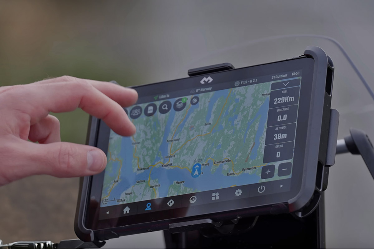
You have invested in a superb Light Hardened Tablet and you have it securely attached to your handlebars with an AMPS arm ? Perfect. Your cockpit is ready. But materially speaking, you were only halfway there. The fateful question remains: What software to use so as not to get lost in the pampa?
Let us be clear at the outset: Waze, Google Maps or Apple Map are your worst off-road enemies. As soon as the tar stops and 4G cuts to the bottom of a valley, these applications become unusable black screens. For trail and enduro, you need applications that can read heavy GPX files, store offline topographic maps and be handled with mud-covered gloves.
Rather than listing you 15 mediocre apps, Freenduro's writing has punctured the paths to select you the Top 5 Off-Road Navigation Apps. From the ultra-precise gas plant to the Dakar-style digital roadbook reader, here is the guide to choosing your weapon.
1. DMD2 (Drive Mode Dashboard): thought for bikers
Price: free of charge (basic functions) | Full subscription: approx. €10 excluding VAT / 6 months or €19 excluding VAT / year | Lifetime modules: OBD2 at 3 € HT, Adventure pack at 5 €
DMD2 is not just a map application, it is an ‘interface’ designed from A to Z to replace the basic interface of your Android tablet. Upon ignition, the screen switches to a typical rally motorcycle environment: large spaced touch pads, a contrasting graphic readable even under the shaving sun and immediate responsiveness without frills.
The application brings together three essential universes on a single interface:
- Off-road navigation: a fluid off-line mapping engine based on OpenStreetMap, capable of recalculating a route by favoring winding roads or tracks, while clearly displaying your GPX trace.
- The native roadbook rally: no need to install a second software for off-road events, DMD2 integrates directly a PDF roadbook reader commandable on the handlebars.
- Engine instrumentation (OBD2): By plugging a Bluetooth adapter into your motorcycle's diagnostic jack, DMD2 displays real-time battery voltage, engine temperature, or actual GPS speed right next to your track.
- The strong point: its unparalleled material integration. The app is calibrated to work in conjunction with physical commodos (DMD Remote, Carpe Iter, Silver Fox) and eliminates the need to touch the screen while rolling.
- The weak point: reserved exclusively for Android devices (no iOS / iPad support).
The Freenduro Field Opinion: it is the royal choice if you have mounted an Android tablet on your motorcycle. Ergonomics avoids risky manipulations in the undergrowth and the price remains very accessible given the level of integration.
2. OsmAnd: the overpowering “gas plant” of exploration
Price: free version (limited to 7 cards offline) | OsmAnd+ (single purchase ~30 €) | OsmAnd Pro (subscription from 10 to 30 € / year depending on weather and relief options)
OsmAnd (for OpenStreetMap Automated Navigation Directions) is the most comprehensive offline mapping software available. If a fire-fighting track, logger trace or forest ford is listed on the globe, it appears on OsmAnd’s maps. The application downloads entire departments, regions or countries directly into the memory of your tablet for total autonomy in the white zone.
Its strength is based on the surgical superposition of layers:
- Level curves and 3D shade: immediately visualising the gradient of the terrain makes it possible to avoid engaging with a large trail in an impassable chasm.
- Advanced off-road management: turn-by-turn voice guidance on the runways, recording of personalised points of interest (POI) with photos and altitude alerts.
- Volume zoom control: the application allows the multimedia volume keys to be natively linked to the front and rear zoom controls.
- The strong point: unparalleled map richness, compatible on both Android and iOS.
- The weak point: a daunting complexity. The menus have dozens of technical subsections. It is necessary to devote several evenings of parameterisation to calm before succeeding in exploiting it serenely on the bike.
The Freenduro Field Opinion: the ultimate tool for long-term darters who leave for several weeks on their own. If you are looking for a basic tool to get started immediately, go your way as OsmAnd requires some learning time
3. Locus Map 4 (or AlpineQuest): The fluid and intuitive Swiss knife
Price: Free Locus Map (bases) / Silver subscription at ~€12 / year or Gold at ~€24 / year | Alternative AlpineQuest: single purchase at 14,99 € (without subscription)
If OsmAnd’s heaviness puts you off, Locus Map 4 (whose logic is very close toAlpineQuest) embodies the perfect balance between topographical precision and ease of use. This is the application acclaimed by a large majority of motorcycle hikers in France and Europe.
Its flagship features precisely meet the needs of Sunday outings:
- Simplified route management: simultaneous display of several dozen GPX tracks with distinct color codes. Convenient to immediately spot easy variants or hard passages prepared for the group.
- Editing in the field: reversing a direction of rotation, splitting a path or bypassing a forbidden area is done in seconds with the fingertip directly on the touch screen.
- Stability and lightness: highly optimised engine that does not suffer from any slowdown, even on entry-level tablets with modest processors.
- The strong point: the clarity of its GPX trace manager and its exemplary fluidity while driving.
- The weak point: available only on Android. The switch to the recurring subscription model for Locus Map pushes some users to AlpineQuest (which retains a one-time payment for life).
The Freenduro Field Opinion: the practical reference for 80 % recreational bikers. You import the buddy's trace the night before, you press start and you ride with peace of mind.
Price: Free Roadbook track to download (in-app purchases and licenses according to options/formats) | Rally Navigator Reader free to ride
Following a red line on a background card is no longer enough for you? To taste the driving of African races and European events (Hellas, Bosnia, TransAnatolia), the digital roadbook is the mandatory step. Applications like the French solution Roadbook Track (developed by LTR) or Rally Navigator replace the mechanical paper unroller of official motorcycles with an electronic scroll on a tablet.
The screen abandons the traditional cartographic view in favour of a pure navigation interface:
- Double kilometre tripmeter: a totalizer counter and a partial counter that can be instantly recalibrated to the nearest decimeter to correct the distance deviations associated with skating the rear wheel.
- Box roller (‘tulips’): fluid display of directional indications, reported hazards (!,!!,!!!) and intermediate distances.
- Heading repeater (CAP): Precision digital compass indispensable for cutting through dunes or plains without any visual cues.
- The strong point: full immersion in the practice of navigation at the heading and the field markers.
- The weak point: requires roadbook files prepared in the specific format (Rally PDF or OpenRally formats) and requires the use of a handlebar control otherwise it will be completely unusable.
The Freenduro Field Opinion: a separate category, reserved for those who prepare a timed event or sports hikes organized in the roadbook.
5. The Trans Euro Trail App (TET) / GPX Viewer: The Plug and Play
Price: 100 % free (volunteer community project funded by donations)
For the biker who has just equipped himself with a screen deported CarPlay / Android Auto (type Carpuride W702) and who wants to go bivouacking on weekends without spending three hours configuring computer files, the official application of the TET is the immediate solution.
The operation is stripped to the maximum to go straight to the goal:
- Direct access to European routes: more than 100,000 kilometres of legal trails maintained and continuously updated by the local representatives of each country (the "Linesmen").
- Zero manual configuration: no need to import or convert files, you select the geographical section and the trace is displayed directly on your map background.
- Verified points of interest: clear identification of isolated service stations, campsites and essential refueling points on an adventure hike.
- The strong point: Get started in two minutes, free of charge and native compatibility with CarPlay and Android Auto systems.
- The weak point: very limited customisation options and the impossibility of editing or modifying routes from the application.
The Freenduro Field Opinion: the Entrance Door 100 % free to take your first steps on Europe’s marked trails without risking a wrong route. But this gratuity comes at a price: Cannot edit a trace by exmple
Comparative table: Which application for your profile?
| Application | Tariff | Getting started | OS compatibility | Handlebar Control Management | Ideal profile |
|---|---|---|---|---|---|
| DMD2 | Free or ~19 € HT / year | Easy (designed motorcycle) | Android only | Perfect (native integration) | Fixed hardened tablet, rallye-raid cockpit |
| OsmAnd | Free or ~10 to 30 € / year (or 30 € for life) | Difficult (very technical) | Android & iOS | Good (zoom via volume keys) | Long-term explorers, distant raids |
| Locus Map 4 / AlpineQuest | 12 to 24 € / year (Locus) or 14,99 € for life (AQ) | Medium (very ergonomic) | Android only | Good (configurable keys) | Rando enduro, management of large GPX packs |
| Roadbook track / Rally Nav. | Free (options according to proofs) | Specific (Tulip reading) | Android & iOS | Mandatory (gauge per metre) | Drivers preparing amateur rallies |
| TET App | 100 % free | Immediate (plug & play) | Android, iOS, CarPlay | Limited (simplified interface) | Beginners in trail, trail running TET |
The essential accessory: the handlebar control (wired or Bluetooth)
Regardless of the application chosen (DMD2, OsmAnd, Locus Map or roadbook reader), there is a golden rule of off-road safety: You never let go of the handlebars in the paths!
Trying to pinch a touch screen with mud-filled gloves to zoom out in the middle of a piercer is the most direct way to end up in the pile. This is where the thumb-deported commands (the famous remotes). Depending on your tablet and budget, two solutions coexist:
1. The wired link: absolute reliability for dedicated hardware
Reserved for tablets and ecosystems cut for rally-raid (such as Carpe Iter or equipment Thork Racing / DMD), this solution connects the control directly to the beam or cradle of the tablet via a waterproof connector (type screwed M8 connector). Zero latency, no internal battery to recharge and no signal failure: this is the indestructible mechanical configuration par excellence.
2. Bluetooth connection: universal, from pro equipment to D system
Essential for hardened consumer tablets (Samsung Galaxy Tab Active, Oukitel RT3…) without a specific port for commodo, the Bluetooth wireless connection offers two options depending on the wallet:
- Pro off-road orders (€100 to €200): models such as the Carpe Iter Adventure Control, the Remotek One, the Silver Fox or craft casings O2R. Mass-cut or moulded in reinforced resin with IP67 sealing, they have real joysticks or industrial push buttons that can be operated without hesitation with large enduro gloves. They allow you to zoom in, refocus the map, navigate through menus or shift roadbook boxes.
- Economic system D (less than €25): for tight budgets, small waterproof Bluetooth multimedia remotes sold on Amazon or AliExpress do the work on a leisurely hike. Recognised as standard audio controllers, their ‘Volume +’ and ‘Volume –’ commands are intercepted natively by applications such as OsmAnd to zoom in and out of the map without going through a third-party remapping application. A limited alternative to zooming, but daunting for the price of an oil can.
The best software in the world is useless if your tablet overheats or flies away on a bump. Finalise your preparation with our comprehensive material guides:
And you, are you rather a fan of the GPX track on Locus Map or navigation on the digital roadbook? What controls do you use on the handlebars? Share your configurations in the comments!
Transparency: this article contains affiliate links. If you decide to purchase equipment via these links, we receive a commission that contributes to the operation of the site and the production of independent comparisons, at no additional cost to your order. Thank you for your support!





Comments
Leave a comment